Property Record
5953 Buford Hwy Ne, Atlanta, GA 30340

NEARBY LISTINGS FOR SALE OR LEASE
Property Detail
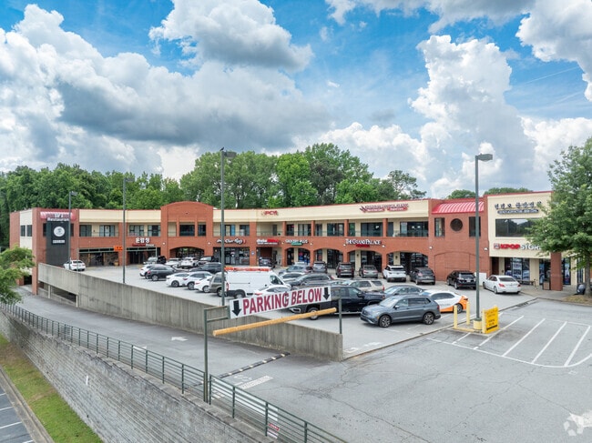
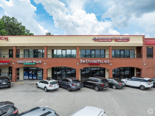
5953 Buford Hwy Ne
Atlanta-Sandy Springs-Roswell, GA
Seoul Plaza
18-337-09-038
224 X 190 X 178 X 161 . . .
Commercialacreage
DeKalb
X
Georgia
13089C0017K
337
2025
2.20 AC
2025
Norcross/Peachtree
021310
Atlanta
DEMOGRAPHICS near 5953 Buford Hwy Ne
1 Mile
3 Mile
5 Mile
2024 Total Population
11,778
98,781
264,617
2029 Population
11,867
99,724
267,836
Pop Growth 2024-2029
+ 0.76%
+ 0.95%
+ 1.22%
Average Age
35
35
37
2024 Total Households
4,111
38,625
103,519
HH Growth 2024-2029
+ 0.97%
+ 0.94%
+ 1.14%
Median Household Inc
$45,790
$54,732
$72,194
Avg Household Size
2.80
2.50
2.50
2024 Avg HH Vehicles
1.00
2.00
2.00
Median Home Value
$275,664
$330,173
$394,261
Median Year Built
1978
1981
1984
Nearby Places
Map Layers
Map Styles
 Street
 Aerial
- Restaurants
- Banks
- Shops
- Fitness
- Groceries
PUBLIC TRANSPORTATION
AIRPORT
Hartsfield - Jackson Atlanta International
DRIVE
WALK
Distance
Hartsfield - Jackson Atlanta International
37 min
25.3 mi
Freight Ports
Georgia Ports - Savannah
DRIVE
WALK
Distance
Georgia Ports - Savannah
293 min
260.5 mi
SALE & LEASE HISTORY
LISTING DATE
SALE/LEASE

Nov 06, 2024
For Lease
May 22, 2023
For Sale
May 04, 2021
For Sale
May 03, 2024
For Sale
Mar 30, 2022
For Sale
Mar 30, 2022
For Sale
Jun 19, 2024
For Sale
Jul 22, 2024
For Sale
Feb 19, 2020
For Sale
Apr 09, 2025
For Sale
Nearby Properties
Address
Land Use
TOTAL SIZE
Lot Size
Zoning
Address
Land Use
TOTAL SIZE
Lot Size
Zoning
705,518 SF
39.09 AC
M
Address
Land Use
TOTAL SIZE
Lot Size
Zoning
602,924 SF
75.93 AC
RM100
Address
Land Use
TOTAL SIZE
Lot Size
Zoning
276,504 SF
3.40 AC
C1
Address
Land Use
TOTAL SIZE
Lot Size
Zoning
103,056 SF
8.66 AC
OI
Address
Land Use
TOTAL SIZE
Lot Size
Zoning
349,619 SF
24.50 AC
RM75
Address
Land Use
TOTAL SIZE
Lot Size
Zoning
524,000 SF
44.93 AC
RM
Address
Land Use
TOTAL SIZE
Lot Size
Zoning
545,074 SF
53.40 AC
RM8
Address
Land Use
TOTAL SIZE
Lot Size
Zoning
283,784 SF
30.88 AC
RM100
Address
Land Use
TOTAL SIZE
Lot Size
Zoning
204,376 SF
14.23 AC
X
Address
Land Use
TOTAL SIZE
Lot Size
Zoning
366,276 SF
11.54 AC
RM-HD
Address
Land Use
TOTAL SIZE
Lot Size
Zoning
317,595 SF
25.50 AC
RM75
Address
Land Use
TOTAL SIZE
Lot Size
Zoning
214,915 SF
3.55 AC
Address
Land Use
TOTAL SIZE
Lot Size
Zoning
358,622 SF
31.01 AC
RM13
Address
Land Use
TOTAL SIZE
Lot Size
Zoning
536,151 SF
30.35 AC
X
Address
Land Use
TOTAL SIZE
Lot Size
Zoning
179,762 SF
4.96 AC
C1
Address
Land Use
TOTAL SIZE
Lot Size
Zoning
303,866 SF
20.13 AC
RM
Address
Land Use
TOTAL SIZE
Lot Size
Zoning
424,948 SF
39.03 AC
RM13
Address
Land Use
TOTAL SIZE
Lot Size
Zoning
503,480 SF
50.04 AC
RM150
Address
Land Use
TOTAL SIZE
Lot Size
Zoning
208,466 SF
20.97 AC
RM
Address
Land Use
TOTAL SIZE
Lot Size
Zoning
230,829 SF
2.74 AC
R1
Address
Land Use
TOTAL SIZE
Lot Size
Zoning
350,038 SF
25.05 AC
X
Address
Land Use
TOTAL SIZE
Lot Size
Zoning
211,544 SF
5.80 AC
RM75
Address
Land Use
TOTAL SIZE
Lot Size
Zoning
475,389 SF
5.37 AC
NX
Address
Land Use
TOTAL SIZE
Lot Size
Zoning
297,057 SF
25 AC
X
Address
Land Use
TOTAL SIZE
Lot Size
Zoning
141,164 SF
4.74 AC
Address
Land Use
TOTAL SIZE
Lot Size
Zoning
249,766 SF
25.34 AC
RM100
Address
Land Use
TOTAL SIZE
Lot Size
Zoning
320,947 SF
29.14 AC
RM
Address
Land Use
TOTAL SIZE
Lot Size
Zoning
185,066 SF
25.53 AC
O-1
Address
Land Use
TOTAL SIZE
Lot Size
Zoning
229,415 SF
10.41 AC
RM-HD
Address
Land Use
TOTAL SIZE
Lot Size
Zoning
313,420 SF
12.74 AC
X
The World's #1 Commercial Real Estate Marketplace
Connect with us
© 2025 CoStar Group
The information above has been obtained from sources believed reliable. While we do not doubt its accuracy we have not verified it and make no guarantee, warranty or representation about it. It is your responsibility to independently confirm its accuracy and completeness. Any projections, opinions, assumptions, or estimates used are for example only and do not represent the current or future performance of the property. The value of this transaction to you depends on tax and other factors which should be evaluated by your tax, financial, and legal advisors. You and your advisors should conduct a careful, independent investigation of the property to determine to your satisfaction the suitability of the property for your needs.